
Don't Miss Out On These 5 Hikes in Hong Kong
Hong Kong is hiking paradise. Even though the city only occupies an area of approximately 2.8km2 (which, in a list of countries and territories makes it one of the smallest in the world), it boasts hundreds of kilometres of prime hiking and running trails.
Here is our list of 5 hikes in Hong Kong that everyone should do least once in a lifetime!
Our List of the 5 Best Hikes in Hong Kong
Note that we did not pick the usual, beginner-friendly hikes that are frequently mentioned on other websites, such as Dragon's Back, Victoria Peak or The Twins (which are all fantastic hikes in their own right). Our list is based on our experience of having lived in Hong Kong and having hiked (almost) everywhere.
Victoria Peak, The Twins and Dragon's Back are great hikes, but they also get very busy at times. Our list contains more advanced hikes, which are less crowded and are not on Hong Kong Island.
So here we go: 5 Hikes in Hong Kong That Everyone Should At Least Do Once!
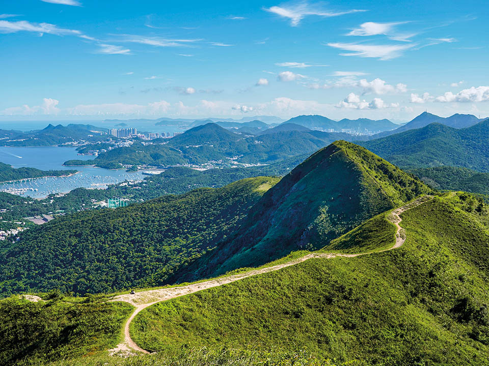
1. Pat Sin Leng or The 8 Immortals
- Location: New Territories
- Start: Hok Tau Reservoir
- Finish: Tai Mei Tuk
- Distance: 11.7km
- Elevation Gain: 970 meters
- Difficulty: Medium
- What's along the way? Nothing! Bring plenty of water & food. There are no stores, vending machines or refill points along the way.
Pat Sin Leng or The 8 Immortals is one of Hong Kong's most scenic hiking routes. It offers stunning views onto the New Territories on one side, and Shenzhen on the other.

Named after eight hills that hikers conquer as the walk along the mountain ridge, The 8 Immortals is a not-to-missed hike while in Hong Kong. It also part of many popular trail running races in Hong Kong, such as the North Face 100, which leads along the Pat Sin Leng Nature Trail.
Viewed from Tai Mei Tuk (at sea level), the 8 Immortals don't look very intimidating - but be prepared for an exhausting hike with a lot of up and down, and make sure to bring plenty of water! Once you're on Pat Sin Leng, you can only complete the hike by finishing it or returning to the start. There's no other way to go down from the mountain ridge.

For the full route, visit Pat Sin Leng - Hiking Trail HK
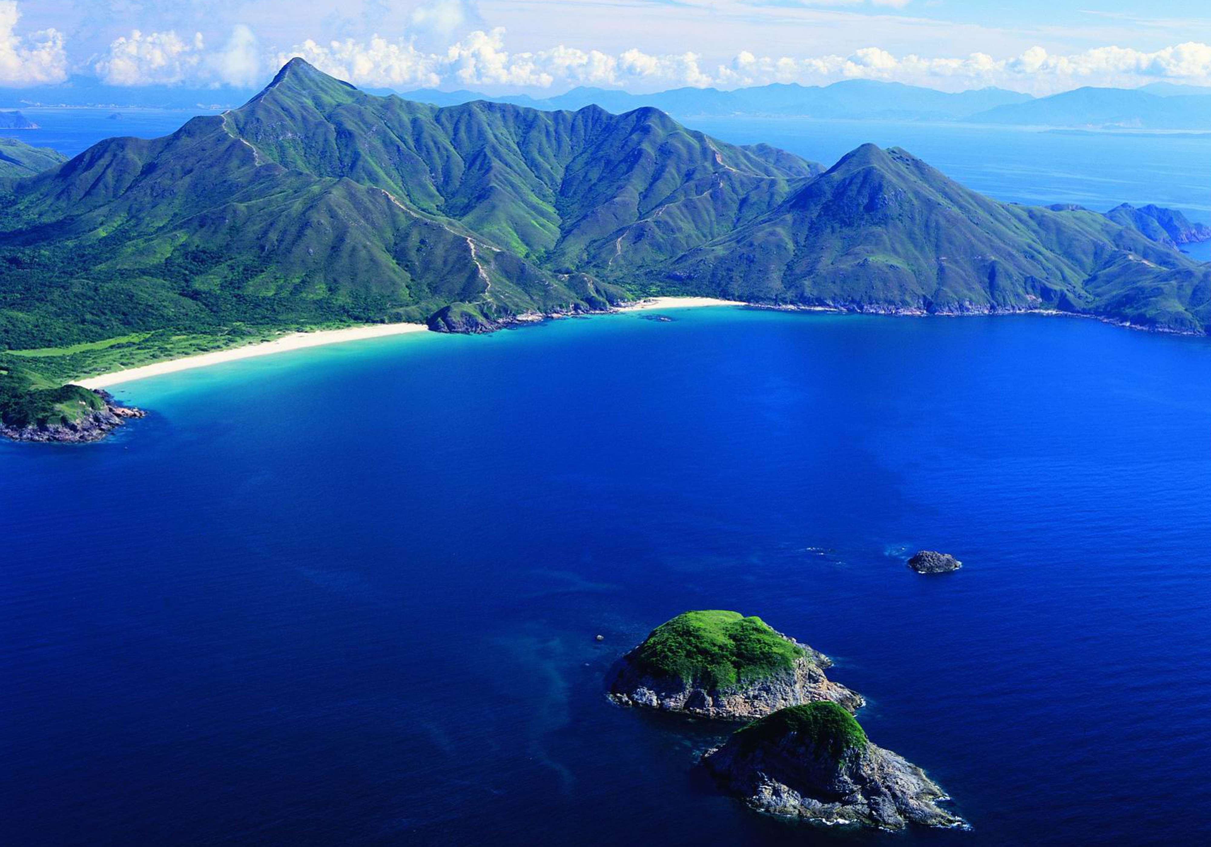
2. Sai Kung - Along the Beaches
- Location: Sai Kung
- Start: Long Ke
- Finish: Pak Tam Au
- Distance: 14.0km
- Elevation Gain: 900 meters
- Difficulty: Medium
- What's along the way? There are restaurants in Ham Tin and Sai Wan, which offer food and drinks.
For short-term visitors of Hong Kong, Sai Kung Country Park is probably one of the best surprises of Hong Kong. Sai Kung has unspoilt beaches, beautiful hiking and running trails, and crystal-clear water to swim in.

There are many beautiful hikes in Sai Kung, but one of the best (and easiest to follow) takes hikers from Long Ke to Pak Tam Au. This hike is also part of the famous MacLehose Trail (Section 2), and there's signage along the way, making it very hard to get lost. Even better, there are restaurants along the way, at both Sai Wan and Ham Tin beach, which offer food and drinks.
For those who do not want to complete the entire hike, there's also the option to get a boat back from Ham Tin to Sai Kung. Note that boats do not run every day and that it is best to check in advance by calling one of the restaurants in Ham Tin, if this is your preferred choice.
One little detour worth doing is visiting Tai Wan beach, Sai Kung's biggest and one of Hong Kong's most beautiful beaches. Pack swimming gear to go for a well-deserved dip along the way!
For the full route (without the detour to Long Ke), visit MacLehose Trail Section 2 - Hiking Trail HK
3. Sharp Peak
- Location: Sai Kung
- Start: Pak Tau Au
- Finish: Pak Tam Au
- Distance: 15.80km
- Elevation Gain: 1100 meters
- Difficulty: Difficult
- What's along the way? Nothing! Bring plenty of water & food. There are no stores, vending machines or refill points along the way.
Here's another great hike in Sai Kung. Unlike the second hike in this list, this one is considered a difficult hike and it's not for the faint-hearted.
Sharp Peak is one of Hong Kong's most recognizable mountain peaks. Its name is a dead giveaway too: it is very sharp and steep!
At 468 meters, Sharp Peak is the highest mountain peak in Sai Kung. Do not attempt this hike, unless you're in good shape and ready to take on a challenge! The hike is very exposed, and can get very hot on the way up. It is also quite rocky and steep, so make sure to be physically ready for a tough uphill and downhill.
Note that for very fit hikers and trail runners who are looking for a longer run with a lot of evalation, there is an option to start at Long Ke, follow the MacLehose Trail - Section 2, and then add Sharp Peak, before finishing at Pak Tam Au. The total distance will easily exceed 25 kilometres, so unless you are a seasoned athlete, do not attempt this!
For the full route, visit Sharp Peak - Hiking Trail HK
4. MacLehose Trail - Stage 4
- Location: Sai Kung & Kowloon
- Start: Kei Ling Ha
- Finish: Tai Lo Shan
- Distance: 12.60km
- Elevation Gain: 1000 meters
- Difficulty: Medium
- What's along the way? Nothing! Bring plenty of water & food. There are no stores, vending machines or refill points along the way.
We are back on the MacLehose Trail. Stage 4 of the MacLehose Trail leads hikers away from Sai Kung and towards Kowloon. Along the way, hikers pass Ma On Shan which offers stunning vistas onto Sai Kung below.
For those who wish to finish in Sai Kung, exit the trail by taking a short-cut by going towards Uk Cheung Village. The trail takes you straight down into the heart of Sai Kung with plenty of great seafood restaurants, as well as public transport options.
For those wishing to finish the entire hike, keep following the signs of the MacLehose Trail. This will take you back into the forest and along a very runnable trail that leads you towards Kowloon. At the finish you'll be rewarded with great views onto Kowloon and Hong Kong Island from Kowloon Peak Viewing Point.
For the full route, visit MacLehose Trail Section 4 - Hiking Trail HK
5. Lantau Island: Mui Wo to Big Buddha
- Location: Lantau Island
- Start: Nam Shan
- Finish: Ngong Ping / Big Buddha
- Distance: 12.40km
- Elevation Gain: 1000 meters
- Difficulty: Medium
- What's along the way? Not much. At Pak Kung Au (after Sunset Peak), there is a bus stop where hikers can exit if they do not wish to climb up Lantau Peak.
No visit to Hong Kong would be complete without a hike on Lantau Island, Hong Kong's "adventure playground" and home to Hong Kong's two highest, climbable peaks, Sunset Peak and Lantau Peak.

This hike follows the famous Lantau Trail from its start in the small coastal town of Mui Wo, which is easily accessible by ferry from Hong Kong Island, all the way to the Big Buddha at Ngong Ping. For those who want to shorten the hike, consider starting at Nam Shan instead (this is our recommendation, because the walk from Mui Wo to Nam Shan just follows a road).
The hike comes packed with lots and lots of elevation, as hikers first go up Sunset Peak, and then Lantau Peak before climbing down towards the Big Buddha. At the Big Buddha, hikers and runners can find all the conveniences of modern day life: a 7/11, Starbucks, restaurants and great public transport options to go to Tung Chung which has an MTR station.
For those who prefer hiking up only of mountain instead of two, our recommendation is starting at Pak Kung Au and going up Lantau Peak. This is a 4.2km hike with 630 meters of elevation and the views are absolutely worth the many, many stairs on the way up!


